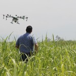
Drones For Farming
Drones can be helpful in many different situations since they can monitor and even deliver tangible items to areas with limited access. In farming especially, drone imagery can provide a close, more in-depth look at crops, without spending excessive time on the fields. In fact, farmers have been using drones for years now.
Because farms are often located in remote areas where powerful computers and networks are few and far between, the shift from centralized computing to edge computing is gaining traction. Aside from agriculture, edge computing is coming into play in many other industries as well. In general, this entails light processing on the periphery of the network, or the edge, as close to the originating source as possible. The end result is faster speeds with less strain on the core network.
With this advanced technology comes more precise, data-driven agriculture. Drones are a much faster, cost-effective way of combing through the field than obtaining images from satellites or planes. These days, drones can be launched and controlled with an app and come equipped to guide itself through the field and take detailed pictures in various lighting environments. Specialized software can then analyze all the data collected to pinpoint problems (ex. dead plants, poor drainage), allowing farmers to address these issues in a prompt manner.
For example, in conjunction with Fieldscanner (the latest product from software vendor DroneDeploy), farmers are able to view their crops in real-time, while the drone is still flying. Via a wireless link, computing takes place on board the drone and on the user’s Apple device.
Previously with DroneDeploy, an expensive drone-based modem and LTE connection was necessary to send photos to the cloud for instant analysis. Now with Fieldscanner, the images are sent to an Apple device in real-time. The need for internet connection is unnecessary thanks to the processing power of both the drone and the mobile device.
Aside from being able to address issues promptly, immediate feedback allows farmers to quickly move on if the area appears fine. This saves network capacity since a more detailed reading is unnecessary. In addition, farmers can upload the data to the computer or a cloud service and produce detailed 3D imagery.
While this drone software is still in beta testing, it is indicative of where the future of drones and farming is headed. What are your thoughts on farming with drones? Share with us on Facebook, Google+, Twitter, LinkedIn, and Pinterest.
Visit SecurityCamExpert.com to browse our inventory of top quality security cameras and CCTV surveillance systems or call us at 888-203-6294 today!
